The Regionals
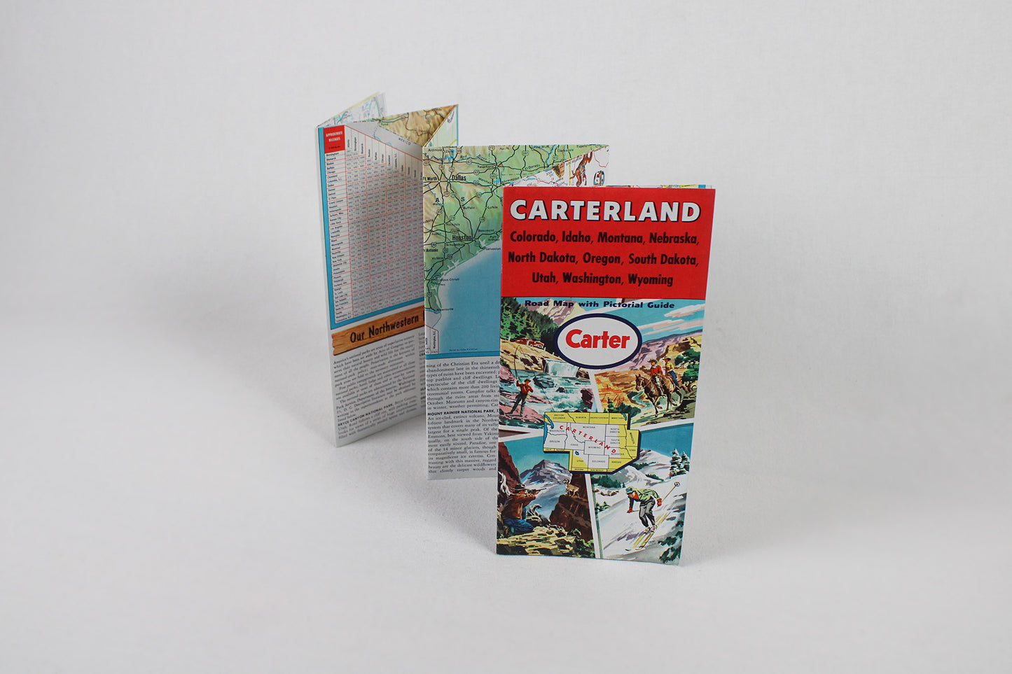
Carter Oil Company, Carterland Northwest U.S. Road Map with Pictorial Guide
Carter Oil Company, Carterland Northwest U.S. Road Map with Pictorial Guide
Couldn't load pickup availability
PACIFIC NORTHWEST / MOUNTAIN WEST / THE PLAINS.
State Roadway Map, Regional Map, Tourist / Sightseeing Map, 1958.
(This fold-out map ships for free.)
“The Carter sign is your guide to Happy Motoring in the Northwest,” proclaims this fantastic piece of proud mid-century car culture. This was an era of well-considered and well executed fold-out road maps that served as extensions of an oil / gas station brand. The better the map, the better the marketing. And in this map, we have a prime example of post-WW2 map craft. But first, some background: John Carter, a Civil War veteran, relocated to northwestern Pennsylvania just as the country’s first oil boom took off in the 1890s. Relocating to West Virginia, Carter continued to invest wisely and innovate. Carter Oil would become so valuable as to be acquired by the behemoth Standard Oil, while keeping its independent brand. John Carter would retire in the 1910s, but not before instituting one of the very first 8-hour work days for all company employees. The company drifted west in search of new fields, along with most of the industry, Carter Oil becoming known for a keen scientific approach to their oil exploration. Setting up first in Tulsa, Oklahoma, and then moving further north to develop oil holdings in Wyoming and Montana, Carter gas stations were soon a ubiquitous site from the Northern Plains to the Pacific Coast. In the 1960s, The Carter Oil Company would merge with Humble and Esso to become Exxon … In fantastic shape, this road map shows marketing innovation as well as attention to the cartographic craft. It is not just a detailed road atlas with extensive mileage charts from the pre-interstate days of the far west, navigating auto-tourists from Fargo and Omaha to Rapid City, Denver, and Cheyenne, Billings and Salt Lake City to Boise, Salem, and Seattle. But the flip side is also cultural boosterism at its finest, advising mid-century motorists to take your time and take in the amazing diverse universe of natural sites to see across the northwestern quadrant of the U.S. Each state showcases a dozen+ illustrations that mix commercial and recreational opportunities characteristic to each along with historic and natural sites: from the Theodore Roosevelt National Park and the Badlands in the Dakotas to Scott’s Bluff, Devil’s Tower, and Royal Gorge in Nebraska, Wyoming, and Colorado, Arches and the Lewis & Clark Trail in Utah and Montana to the Sawtooth Range, Crater Lake, and the Grand Coulee Dam in Idaho, Oregon, and Washington. Insets give special attention to far west national parks too. Here is a fantastic example of commercial art prowess in marketing a brand along with a practical guide that got motorists from place to place with ease. It is possible that it was never used. The map is in pristine condition.
Condition: Used Very Good.
Travel Related.
Dimensions: 4” wide x 8.5” high (folded) / 24” wide x 33” high (unfolded)
1 in stock